Introduction: How Did People Find Their Way Before GPS?
Before a calm voice told us to “turn left in 200 meters,” humans relied on ancient navigation techniques, using their eyes, ears, skin, and memory to move through the world. So how did people find their way before GPS? The short answer is: they learned the landscape so deeply that direction became a feeling.
My core belief is this: before GPS, wayfinding was a multi-sensory art form, not a single technique. It combined astronomy, ecology, storytelling, rhythm, and lived experience. To know where you were going, you had to know the land—and to know the land, you had to listen.
What Is Wayfinding, Really?
More Than Navigation
Wayfinding isn’t just getting from Point A to Point B. It’s the ability to orient yourself within a living landscape—to understand where you are in relation to the sun, the wind, the slope of the ground, and the stories embedded in place.
Modern navigation is external. Traditional wayfinding was internalized.
When Did Humans Begin Navigating Without Modern Tools?
As soon as humans migrated beyond familiar territories. Tens of thousands of years ago, people crossed deserts, forests, oceans, and tundra without maps or compasses—relying on pattern recognition and environmental literacy
Who Used Natural Wayfinding Methods Before GPS?
A Universal Human Skill
Natural wayfinding wasn’t niche. It was used by:
- Hunters and gatherers
- Traders and pilgrims
- Sailors and fishers
- Shepherds and nomads
Children learned routes the way we learn street names—by repetition and story.
Who Passed Down This Knowledge?
Wayfinding knowledge was inherited, not invented:
- Elders taught by walking
- Parents taught by pointing
- Communities taught through ritual and song
Direction was cultural memory, not written instruction.
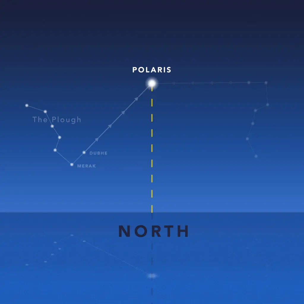
The Sky as a Map: Navigating by Stars
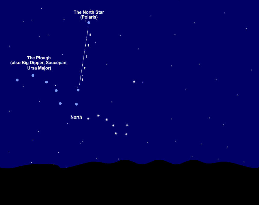
Why Were Stars So Important?
Stars are predictable. Long before clocks and calendars, the sky offered a reliable grid. Travelers learned:
- Which stars rose and set where
- How constellations shifted with seasons
- How star paths indicated latitude
The night sky wasn’t decoration—it was infrastructure.
Where Were Stars Used as Primary Navigation Tools?
- Open oceans
- Deserts
- Steppe lands
- Polar regions
Anywhere landmarks disappeared, the sky took over.
How Did People Navigate Using Constellations?
Not by memorizing charts, but by watching movement. Direction came from relationships:
- This star rises after that one
- This path leads home in winter
- That cluster marks danger
Navigation was dynamic, not fixed.
Moss, Trees, and the Language of Landscapes
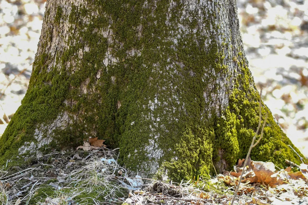
Did Moss Really Grow Only on One Side?
Not exactly—and that’s the point. Wayfinders didn’t rely on a single sign. They read clusters of evidence:
- Moss density
- Tree growth patterns
- Snow melt direction
- Wind-shaped branches
One sign could lie. Many signs together told the truth.
Where Did People Use Landscape Cues Most?
- Dense forests
- Mountain passes
- Arctic tundra
- Grasslands
The land itself became a living compass.
Which Natural Indicators Were Most Reliable?
- Sun arc and shadow length
- Prevailing winds
- Water flow patterns
- Animal paths
Wayfinding was environmental literacy at its highest level.
Folk Songs as Maps You Could Carry

Why Use Songs for Navigation?
Because songs are hard to forget.
Folk songs encoded:
- Routes
- Landmarks
- Hazards
- Distances
If you could sing the journey, you could walk it.
How Did Folk Songs Encode Directions?
Through rhythm and sequence:
- Verse one = the river bend
- Chorus = the mountain pass
- Final line = home
Songs transformed geography into memory.

Why Communities Relied on Oral Maps
Written maps were fragile. Songs lived in people. They traveled across generations intact, adapting slightly but never disappearing.
Dead Reckoning: Knowing Where You Are Without Seeing It
What Is Dead Reckoning?
Dead reckoning is navigation by continuous awareness:
- Speed
- Direction
- Time
- Movement
It’s how sailors, pilots, and travelers knew where they were even when visibility failed.
How Was Dead Reckoning Used Before GPS?
By constant adjustment. If you drifted, you noticed—because your body was paying attention.
Modern GPS encourages passive movement. Dead reckoning demanded presence.
How Pilots and Sailors Navigated Before GPS
Before Cockpits Had Screens
Pilots used:
- Visual landmarks
- Wind drift calculations
- Sun position
Sailors combined:
- Star paths
- Swell direction
- Bird behavior
Navigation was a conversation with nature.
When and Why Traditional Wayfinding Declined
When Did Wayfinding Begin to Fade?
Gradually, then suddenly:
- Compasses reduced sky-reading
- Maps replaced oral routes
- GPS eliminated memory
Each innovation removed one layer of human engagement.
What We Gained—and Lost
We gained speed and precision.
We lost awareness, intuition, and spatial confidence.
A Personal Observation: GPS Didn’t Just Replace Maps—it Replaced Attention
Here’s what stands out to me after studying these traditions.
Traditional wayfinders were never lost in the modern sense. They might not know their exact position, but they understood their relationship to the world around them.
Today, we know our coordinates but often feel disoriented without a screen. GPS didn’t just automate navigation—it outsourced perception.
Learning pre-GPS methods doesn’t reject technology. It reminds us how much intelligence the human body once carried.
Can Traditional Wayfinding Still Be Used Today?
Yes—and It Changes How You Move
People who learn basic wayfinding report:
- Better spatial awareness
- Reduced anxiety when traveling
- Stronger connection to place
You start noticing things again.
Can It Improve Spatial Intelligence?
Absolutely. Wayfinding trains:
- Memory
- Pattern recognition
- Environmental awareness
It turns movement into learning.
What Pre-GPS Wayfinding Teaches Us About Humanity
Wayfinding wasn’t just survival—it was culture.
It taught:
- Patience
- Observation
- Respect for environment
- Intergenerational trust
Navigation was communal knowledge, not private data.
Conclusion: Finding Our Way Back to Awareness
Before GPS, people didn’t just travel through landscapes—they belonged to them. Stars weren’t distant objects. Moss wasn’t decoration. Songs weren’t entertainment. They were tools.
Understanding this history doesn’t mean abandoning technology. It means remembering that we were once designed to navigate the world with our senses fully awake.
Maybe the most important direction we can relearn isn’t north or south—but attention.
FAQs
What ancient navigation techniques did people use before GPS?
Ancient navigation techniques included reading stars and constellations, observing the sun and winds, following landscape cues, and relying on oral traditions like songs and stories.
FAQ 2: How did people get around before GPS?
Through environmental awareness, learned routes, dead reckoning, and community-shared navigation knowledge.
FAQ 3: Were folk songs really used for navigation?
Yes. Many cultures encoded directions and landmarks into songs to preserve routes across generations.
FAQ 4: Is moss a reliable tool in ancient navigation techniques?
Moss can support ancient navigation techniques, but it was never used alone. Traditional wayfinders combined moss growth with multiple environmental signs to confirm direction.
FAQ 5: Can learning pre-GPS navigation help today?
Yes. It improves spatial awareness, confidence, and attention—even when modern tools fail.